Pagodas & temples in Hải Phòng
117 pagodas, temples, communal houses, shrines and monasteries in Hải Phòng — with a map and detail pages for each site.
Pagodas & viharas (68)Communal houses (19)Temples (19)Shrines (10)Other (1)

Chùa An Ninh
An Ninh Pagoda (安寧寺), with the formal name Vĩnh Khánh Tự (永慶寺), popularly known as the 'Hundred-Bay Pagoda of the East', is located in Vạn Lộng hamlet, later renamed An Ninh and then An Đông, in An Phú commune, Hải Phòng city. The pagoda dates back to the Trần dynasty, was restored during the Lê and Nguyễn dynasties, and currently retains 85 bays, 37 wooden statues, hundreds of printed Buddhist sutras, and many valuable antiquities. This is a large pagoda with architecture that remains quite intact. Every year, on the 13th day of the 9th lunar month, the pagoda holds a festival. An Ninh Pagoda was recognised as a heritage site in 1990.
🏯
Chùa Bạch Hào
Hào Xá Pagoda, also known as Hào Pagoda (in Sino-Vietnamese called Bạch Hào cổ thiền tự 白豪古禪寺), is located in Hào Xá village, Thanh Hà commune, Hải Phòng city; it was built during the Lý dynasty. This pagoda features picturesque river scenery and possesses many unique characteristics of the Red River Delta region. It was recognised as a national historical site in 1993 and again in 2015; the Hào Xá Pagoda festival is a national intangible cultural heritage.

Chùa Côn Sơn
Côn Sơn Pagoda (its formal name is Thiên Tư Phúc tự or Côn Sơn Tự), also known as Chùa Hun, is a pagoda located beside Côn Sơn Mountain (also known as Hun Mountain) in Trần Hưng Đạo Ward, Hải Phòng City, Vietnam. The pagoda was classified as a national relic by the Minister of Culture of the Democratic Republic of Vietnam in the first round of 1962. This is an important relic belonging to the Côn Sơn - Kiếp Bạc relic complex, which was recognised as a special national relic in 2012.
🏯
Chùa Đồng Ngọ
Động Ngọ Pagoda (Chinese characters: 洞午寺, transliteration: Động Ngọ Tự) is an ancient pagoda located in Cập Nhất village, Nam Đồng ward, Hải Phòng city. Động Ngọ Pagoda is one of the two oldest pagodas of the former Hải Dương province. National Preceptor Khuông Việt built this pagoda in 971 by imperial order of King Đinh Tiên Hoàng. Today, the pagoda bears many marks of late 17th-century architectural art, belongs to the Northern School (Bắc tông) tradition, and is recognised as a national historical and cultural relic.
🏯
Chùa Giám
Giám Pagoda (formal name: Nghiêm Quang Tự) (Chinese characters: 嚴光寺) is a pagoda located in Cẩm Giàng commune, Hải Phòng city. This is a unique Buddhist structure found only in Vietnam.
🏯
Chùa Minh Khánh
Minh Khánh Pagoda (also known as Hương Đại Pagoda or Hương Pagoda) is located in Bình Hà village, Thanh Hà commune, Hải Phòng city. It belongs to the Northern School (Bắc tông) of Buddhism, worships the Buddha and King Trần Nhân Tông, and was recognised as a National Historical and Cultural Site in 1990.

Chùa Thanh Mai
Thanh Mai Pagoda (formal name: Thanh Mai tự) is a renowned site originally belonging to Thanh Mai village, Phưỡng Nhãn district, Kinh Bắc, now located in the Thanh Mai residential group, Nguyễn Trãi ward, Hải Phòng city, Vietnam. The pagoda was built around the year 1329 by Zen Master Pháp Loa Tôn Giả, closely associated with his life and career as the second patriarch of the Trúc Lâm Yên Tử Zen sect.

Chùa Đót Sơn
Đót Sơn Pagoda (also known as Đót Pagoda) is an ancient pagoda located in Cấp Tiến Commune, Tiên Lãng District, Hải Phòng. This is the place where the Holy Patriarch Huyền Quang practised and is home to a Bodhi tree of Indian origin that is over a thousand years old. The pagoda is situated in Quan Bồ Hamlet, Cấp Tiến Commune, but formerly belonged to Kinh Lương Canton, old Tiên Lãng.
🏯
Chùa Hang (Đồ Sơn)
Chùa Hang, also known as Cốc Tự, is a Buddhist pagoda located in Zone 1, Đồ Sơn Ward, Hải Phòng City. It is considered the largest naturally formed pagoda within the Đồ Sơn historical site complex. Many Vietnamese researchers believe that this is the first place where Buddhism was introduced into Vietnam, dating back to the 2nd century BCE.
🏯
Chùa Phúc Lâm (Hải Phòng)
Dư Hàng Pagoda (its formal name is Phúc Lâm Tự) is an ancient pagoda, built during the Early Lê dynasty; it is a centre of Buddhism, spiritual tourism, and a nationally recognised historical and cultural site. The pagoda is located at 121 Chùa Hàng Street, Lê Chân District.
🏯
Chùa Trà Phương
Trà Phương Pagoda, also known as Bà Đanh Pagoda, with the formal name Thiên Phúc Tự, is an ancient pagoda located in Trà Phương village, Thụy Hương commune, Kiến Thụy district, on the outskirts of Hải Phòng city. In 2007, the pagoda was recognised by the state as a national architectural and artistic heritage site. According to some remaining stone artefacts, many historians and art researchers believe that this pagoda was first built during the Lý dynasty.

Chùa Cao Linh
Cao Linh Pagoda is located in Bac Ha hamlet, Bac Son commune, An Duong district, at the western gateway of Hai Phong, about 12 km from the city center. Covering roughly 49,000 m², it is one of the largest pagodas in Hai Phong, facing the Thien Van mountain range with the Ha Lien river behind.
🏯
Tháp Tường Long (Chùa Tháp)
Tuong Long Tower, also known as Thap Pagoda or Do Son Tower, stands on the 95.2 m summit of Long Son — the first of nine hills running along the Do Son peninsula — in Van Huong ward, Do Son district, Hai Phong.
🏯
Chùa Đỏ (Linh Độ tự)
Do Pagoda (Red Pagoda), formally Linh Do Tu, lies in a small lane off Le Lai street in Ngo Quyen district, Hai Phong. It is considered one of the most sacred pagodas of the port city and is ranked a national relic.

Chùa Vẽ (Hoa Linh tự)
Ve Pagoda, formally Hoa Linh Tu, lies about 5 km northeast of central Hai Phong at the end of Da Nang street in Dong Hai ward, Hai An district. It forms a relic cluster with Thuong Doan Palace and Phu Xa Temple beside the historic Bach Dang river, and was ranked a national architecture-and-art relic in 1994.
🏯
Chùa Mõ
Mo Pagoda belongs to the Mo temple-and-pagoda relic cluster in Ngu Phuc commune, Kien Thuy district, Hai Phong. The cluster is a nationally ranked historical-cultural relic and is famous for a giant silk-cotton tree over 700 years old.
🏯
Chùa Phổ Chiếu
Pho Chieu Pagoda stands in Du Hang Kenh ward, Le Chan district, about 1.5 km from central Hai Phong. Although founded only in the 1950s, it has the solemn, ancient look of an old temple with several distinctive structures in its grounds.
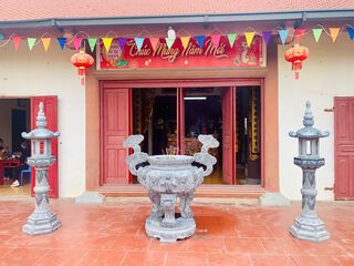
Đình Làng Trạm Bạc
Tram Bac Communal House (Đình Trạm Bạc), together with the tomb of the progenitor of the Nguyen Dinh and Nguyen Khoa lineages, stands in Tram Bac hamlet, Le Loi commune, An Duong district, Hai Phong, about 4 km from the district center. It is a traditional spiritual and cultural architectural work of the people of Tram Bac village.
🏯
Chùa Bùi
Chùa Bùi is a Buddhist pagoda in Hải Phòng (formerly Hải Dương province), Vietnam. Its location comes from OpenStreetMap community data; further details will be added when reliable sources become available.
🏯
Chùa Cả
Chùa Cả is a Buddhist pagoda in Hải Phòng (formerly Hải Dương province), Vietnam. Its location comes from OpenStreetMap community data; further details will be added when reliable sources become available.
🏯
Chùa Cảnh Linh
Chùa Cảnh Linh is a Buddhist pagoda in Hải Phòng (formerly Hải Dương province), Vietnam. Its location comes from OpenStreetMap community data; further details will be added when reliable sources become available.
🏯
Chùa Du Tiên
Chùa Du Tiên is a Buddhist pagoda in Hải Phòng (formerly Hải Dương province), Vietnam. Its location comes from OpenStreetMap community data; further details will be added when reliable sources become available.
🏯
Chùa Đại Khánh
Chùa Đại Khánh is a Buddhist pagoda in Hải Phòng (formerly Hải Dương province), Vietnam. Its location comes from OpenStreetMap community data; further details will be added when reliable sources become available.
🏯
Chùa Đò
Chùa Đò is a Buddhist pagoda in Hải Phòng (formerly Hải Dương province), Vietnam. Its location comes from OpenStreetMap community data; further details will be added when reliable sources become available.
🏯
Chùa Đống Cao
Chùa Đống Cao is a Buddhist pagoda in Hải Phòng (formerly Hải Dương province), Vietnam. Its location comes from OpenStreetMap community data; further details will be added when reliable sources become available.
🏯
Chùa Đống Duyên
Chùa Đống Duyên is a Buddhist pagoda in Hải Phòng (formerly Hải Dương province), Vietnam. Its location comes from OpenStreetMap community data; further details will be added when reliable sources become available.
🏯
Chùa Đồng Neo
Chùa Đồng Neo is a Buddhist pagoda in Hải Phòng (formerly Hải Dương province), Vietnam. Its location comes from OpenStreetMap community data; further details will be added when reliable sources become available.
🏯
Chùa Đông Thuần
Chùa Đông Thuần is a Buddhist pagoda in Hải Phòng (formerly Hải Dương province), Vietnam. Its location comes from OpenStreetMap community data; further details will be added when reliable sources become available.
🏯
Chùa Gạo
Chùa Gạo is a Buddhist pagoda in Hải Phòng (formerly Hải Dương province), Vietnam. Its location comes from OpenStreetMap community data; further details will be added when reliable sources become available.
🏯
Chùa Hưng Long
Chùa Hưng Long is a Buddhist pagoda in Hải Phòng (formerly Hải Dương province), Vietnam. Its location comes from OpenStreetMap community data; further details will be added when reliable sources become available.
🏯
Chùa Hưng Phúc
Chùa Hưng Phúc is a Buddhist pagoda in Hải Phòng (formerly Hải Dương province), Vietnam. Its location comes from OpenStreetMap community data; further details will be added when reliable sources become available.
🏯
Chùa Kim Độ
Chùa Kim Độ is a Buddhist pagoda in Hải Phòng (formerly Hải Dương province), Vietnam. Its location comes from OpenStreetMap community data; further details will be added when reliable sources become available.
🏯
Chùa Linh Thông
Chùa Linh Thông is a Buddhist pagoda in Hải Phòng (formerly Hải Dương province), Vietnam. Its location comes from OpenStreetMap community data; further details will be added when reliable sources become available.
🏯
Chùa Lôi Âm
Chùa Lôi Âm is a Buddhist pagoda in Hải Phòng (formerly Hải Dương province), Vietnam. Its location comes from OpenStreetMap community data; further details will be added when reliable sources become available.
🏯
Chùa Ngo
Chùa Ngo is a Buddhist pagoda in Hải Phòng (formerly Hải Dương province), Vietnam. Its location comes from OpenStreetMap community data; further details will be added when reliable sources become available.
🏯
Chùa Sùng Nghiêm
Chùa Sùng Nghiêm is a Buddhist pagoda in Hải Phòng (formerly Hải Dương province), Vietnam. Its location comes from OpenStreetMap community data; further details will be added when reliable sources become available.
🏯
Chùa Tây Hà
Chùa Tây Hà is a Buddhist pagoda in Hải Phòng (formerly Hải Dương province), Vietnam. Its location comes from OpenStreetMap community data; further details will be added when reliable sources become available.
🏯
Chùa Trung Sơn
Chùa Trung Sơn is a Buddhist pagoda in Hải Phòng (formerly Hải Dương province), Vietnam. Its location comes from OpenStreetMap community data; further details will be added when reliable sources become available.
🏯
Chùa Xưa
Chùa Xưa is a Buddhist pagoda in Hải Phòng (formerly Hải Dương province), Vietnam. Its location comes from OpenStreetMap community data; further details will be added when reliable sources become available.
🏯
Đền An Liệt
Đền An Liệt is a temple (đền) in Hải Phòng (formerly Hải Dương province), Vietnam. Its location comes from OpenStreetMap community data; further details will be added when reliable sources become available.
🏯
Đền Bia
Đền Bia is a temple (đền) in Hải Phòng (formerly Hải Dương province), Vietnam. Its location comes from OpenStreetMap community data; further details will be added when reliable sources become available.
🏯
Đền Chu Văn An
Đền Chu Văn An is a temple (đền) in Hải Phòng (formerly Hải Dương province), Vietnam. Its location comes from OpenStreetMap community data; further details will be added when reliable sources become available.

Đền Kiếp Bạc
Đền Kiếp Bạc is a temple (đền) in Hải Phòng (formerly Hải Dương province), Vietnam. Its location comes from OpenStreetMap community data; further details will be added when reliable sources become available.
🏯
Đền Mẫu
Đền Mẫu is a temple (đền) in Hải Phòng (formerly Hải Dương province), Vietnam. Its location comes from OpenStreetMap community data; further details will be added when reliable sources become available.
🏯
Đền Quốc Phụ
Đền Quốc Phụ is a temple (đền) in Hải Phòng (formerly Hải Dương province), Vietnam. Its location comes from OpenStreetMap community data; further details will be added when reliable sources become available.
🏯
Đền Tam Phủ
Đền Tam Phủ is a temple (đền) in Hải Phòng (formerly Hải Dương province), Vietnam. Its location comes from OpenStreetMap community data; further details will be added when reliable sources become available.
🏯
Đền thờ Bà chúa Sao Sa
Đền thờ Bà chúa Sao Sa is a temple (đền) in Hải Phòng (formerly Hải Dương province), Vietnam. Its location comes from OpenStreetMap community data; further details will be added when reliable sources become available.
🏯
Đền Xưa
Đền Xưa is a temple (đền) in Hải Phòng (formerly Hải Dương province), Vietnam. Its location comes from OpenStreetMap community data; further details will be added when reliable sources become available.
🏯
Đình Chùa Văn Xá
Đình Chùa Văn Xá is a village communal house (đình) in Hải Phòng (formerly Hải Dương province), Vietnam. Its location comes from OpenStreetMap community data; further details will be added when reliable sources become available.
🏯
Đình Làng Cập Nhất
Đình Làng Cập Nhất is a village communal house (đình) in Hải Phòng (formerly Hải Dương province), Vietnam. Its location comes from OpenStreetMap community data; further details will be added when reliable sources become available.
🏯
Đình Lôi Động
Đình Lôi Động is a village communal house (đình) in Hải Phòng (formerly Hải Dương province), Vietnam. Its location comes from OpenStreetMap community data; further details will be added when reliable sources become available.
🏯
Đình Nhân Nghĩa
Đình Nhân Nghĩa is a village communal house (đình) in Hải Phòng (formerly Hải Dương province), Vietnam. Its location comes from OpenStreetMap community data; further details will be added when reliable sources become available.
🏯
Đình Phú An
Đình Phú An is a village communal house (đình) in Hải Phòng (formerly Hải Dương province), Vietnam. Its location comes from OpenStreetMap community data; further details will be added when reliable sources become available.
🏯
Đình Thanh Trung
Đình Thanh Trung is a village communal house (đình) in Hải Phòng (formerly Hải Dương province), Vietnam. Its location comes from OpenStreetMap community data; further details will be added when reliable sources become available.
🏯
Đình Xuân An
Đình Xuân An is a village communal house (đình) in Hải Phòng (formerly Hải Dương province), Vietnam. Its location comes from OpenStreetMap community data; further details will be added when reliable sources become available.
🏯
Miếu Cầu
Miếu Cầu is a shrine (miếu) in Hải Phòng (formerly Hải Dương province), Vietnam. Its location comes from OpenStreetMap community data; further details will be added when reliable sources become available.
🏯
Miếu Cầu (Miếu Vàng)
Miếu Cầu (Miếu Vàng) is a shrine (miếu) in Hải Phòng (formerly Hải Dương province), Vietnam. Its location comes from OpenStreetMap community data; further details will be added when reliable sources become available.
🏯
Miếu Đình Tứ Giáp
Miếu Đình Tứ Giáp is a shrine (miếu) in Hải Phòng (formerly Hải Dương province), Vietnam. Its location comes from OpenStreetMap community data; further details will be added when reliable sources become available.
🏯
Miếu Nhân Lỳ
Miếu Nhân Lỳ is a shrine (miếu) in Hải Phòng (formerly Hải Dương province), Vietnam. Its location comes from OpenStreetMap community data; further details will be added when reliable sources become available.
🏯
Chùa An Tường
Chùa An Tường is a Buddhist pagoda in Hải Phòng, Vietnam. Its location comes from OpenStreetMap community data; further details will be added when reliable sources become available.
🏯
Chùa Bảo Phúc
Chùa Bảo Phúc is a Buddhist pagoda in Hải Phòng, Vietnam. Its location comes from OpenStreetMap community data; further details will be added when reliable sources become available.
🏯
Chùa Bảo Quang
Chùa Bảo Quang is a Buddhist pagoda in Hải Phòng, Vietnam. Its location comes from OpenStreetMap community data; further details will be added when reliable sources become available.
🏯
Chùa Bến
Chùa Bến is a Buddhist pagoda in Hải Phòng, Vietnam. Its location comes from OpenStreetMap community data; further details will be added when reliable sources become available.
🏯
Chùa Bính
Chùa Bính is a Buddhist pagoda in Hải Phòng, Vietnam. Its location comes from OpenStreetMap community data; further details will be added when reliable sources become available.
🏯
Chùa Cách Hạ
Chùa Cách Hạ is a Buddhist pagoda in Hải Phòng, Vietnam. Its location comes from OpenStreetMap community data; further details will be added when reliable sources become available.
🏯
Chùa Cao Thiên
Chùa Cao Thiên is a Buddhist pagoda in Hải Phòng, Vietnam. Its location comes from OpenStreetMap community data; further details will be added when reliable sources become available.
🏯
Chùa Cống Mỹ
Chùa Cống Mỹ is a Buddhist pagoda in Hải Phòng, Vietnam. Its location comes from OpenStreetMap community data; further details will be added when reliable sources become available.
🏯
Chùa Dương Quan
Chùa Dương Quan is a Buddhist pagoda in Hải Phòng, Vietnam. Its location comes from OpenStreetMap community data; further details will be added when reliable sources become available.
🏯
Chùa Đông Chấn
Chùa Đông Chấn is a Buddhist pagoda in Hải Phòng, Vietnam. Its location comes from OpenStreetMap community data; further details will be added when reliable sources become available.
🏯
Chùa Hải Ninh
Chùa Hải Ninh is a Buddhist pagoda in Hải Phòng, Vietnam. Its location comes from OpenStreetMap community data; further details will be added when reliable sources become available.
🏯
Chùa Hàm Long
Chùa Hàm Long is a Buddhist pagoda in Hải Phòng, Vietnam. Its location comes from OpenStreetMap community data; further details will be added when reliable sources become available.
🏯
Chùa Hang Lương
Chùa Hang Lương is a Buddhist pagoda in Hải Phòng, Vietnam. Its location comes from OpenStreetMap community data; further details will be added when reliable sources become available.
🏯
Chùa Huệ Hương
Chùa Huệ Hương is a Buddhist pagoda in Hải Phòng, Vietnam. Its location comes from OpenStreetMap community data; further details will be added when reliable sources become available.
🏯
Chùa Hưng Khánh
Chùa Hưng Khánh is a Buddhist pagoda in Hải Phòng, Vietnam. Its location comes from OpenStreetMap community data; further details will be added when reliable sources become available.
🏯
Chùa Khánh Long
Chùa Khánh Long is a Buddhist pagoda in Hải Phòng, Vietnam. Its location comes from OpenStreetMap community data; further details will be added when reliable sources become available.
🏯
Chùa Linh Quang
Chùa Linh Quang is a Buddhist pagoda in Hải Phòng, Vietnam. Its location comes from OpenStreetMap community data; further details will be added when reliable sources become available.
🏯
Chùa Linh Quang
Chùa Linh Quang is a Buddhist pagoda in Hải Phòng, Vietnam. Its location comes from OpenStreetMap community data; further details will be added when reliable sources become available.
🏯
Chùa Linh Quang
Chùa Linh Quang is a Buddhist pagoda in Hải Phòng, Vietnam. Its location comes from OpenStreetMap community data; further details will be added when reliable sources become available.
🏯
Chùa Linh Sơn
Chùa Linh Sơn is a Buddhist pagoda in Hải Phòng, Vietnam. Its location comes from OpenStreetMap community data; further details will be added when reliable sources become available.
🏯
Chùa Long Hoa
Chùa Long Hoa is a Buddhist pagoda in Hải Phòng, Vietnam. Its location comes from OpenStreetMap community data; further details will be added when reliable sources become available.
🏯
Chùa Lương Xâm
Chùa Lương Xâm is a Buddhist pagoda in Hải Phòng, Vietnam. Its location comes from OpenStreetMap community data; further details will be added when reliable sources become available.
🏯
Chùa Nam Hải
Chùa Nam Hải is a Buddhist pagoda in Hải Phòng, Vietnam. Its location comes from OpenStreetMap community data; further details will be added when reliable sources become available.
🏯
Chùa Nguyệt Quang
Chùa Nguyệt Quang is a Buddhist pagoda in Hải Phòng, Vietnam. Its location comes from OpenStreetMap community data; further details will be added when reliable sources become available.
🏯
Chùa Phủ Lễ
Chùa Phủ Lễ is a Buddhist pagoda in Hải Phòng, Vietnam. Its location comes from OpenStreetMap community data; further details will be added when reliable sources become available.
🏯
Chùa Quỳnh Đẩu
Chùa Quỳnh Đẩu is a Buddhist pagoda in Hải Phòng, Vietnam. Its location comes from OpenStreetMap community data; further details will be added when reliable sources become available.
🏯
Chùa Tây Sơn
Chùa Tây Sơn is a Buddhist pagoda in Hải Phòng, Vietnam. Its location comes from OpenStreetMap community data; further details will be added when reliable sources become available.
🏯
Chùa Tháp Tường Long
Chùa Tháp Tường Long is a Buddhist pagoda in Hải Phòng, Vietnam. Its location comes from OpenStreetMap community data; further details will be added when reliable sources become available.
🏯
Chùa Tiểu Trà
Chùa Tiểu Trà is a Buddhist pagoda in Hải Phòng, Vietnam. Its location comes from OpenStreetMap community data; further details will be added when reliable sources become available.
🏯
Chùa Tràng Kênh
Chùa Tràng Kênh is a Buddhist pagoda in Hải Phòng, Vietnam. Its location comes from OpenStreetMap community data; further details will be added when reliable sources become available.
🏯
Chùa Vĩnh Khánh Phương Lưu
Chùa Vĩnh Khánh Phương Lưu is a Buddhist pagoda in Hải Phòng, Vietnam. Its location comes from OpenStreetMap community data; further details will be added when reliable sources become available.
🏯
Đền Bát Tràng
Đền Bát Tràng is a temple (đền) in Hải Phòng, Vietnam. Its location comes from OpenStreetMap community data; further details will be added when reliable sources become available.
🏯
Đền Nghè
Đền Nghè is a temple (đền) in Hải Phòng, Vietnam. Its location comes from OpenStreetMap community data; further details will be added when reliable sources become available.
🏯
Đền Phú Xá
Đền Phú Xá is a temple (đền) in Hải Phòng, Vietnam. Its location comes from OpenStreetMap community data; further details will be added when reliable sources become available.
🏯
Đền Tam Kì
Đền Tam Kì is a temple (đền) in Hải Phòng, Vietnam. Its location comes from OpenStreetMap community data; further details will be added when reliable sources become available.
🏯
Đền thờ Bác Hồ
Đền thờ Bác Hồ is a temple (đền) in Hải Phòng, Vietnam. Its location comes from OpenStreetMap community data; further details will be added when reliable sources become available.
🏯
Đền thờ Đức Thánh Trần
Đền thờ Đức Thánh Trần is a temple (đền) in Hải Phòng, Vietnam. Its location comes from OpenStreetMap community data; further details will be added when reliable sources become available.
🏯
Đền thờ Đức Thánh Vương Ngô Quyền
Đền thờ Đức Thánh Vương Ngô Quyền is a temple (đền) in Hải Phòng, Vietnam. Its location comes from OpenStreetMap community data; further details will be added when reliable sources become available.
🏯
Đền thờ Hoàng đế Lê Đại Hành
Đền thờ Hoàng đế Lê Đại Hành is a temple (đền) in Hải Phòng, Vietnam. Its location comes from OpenStreetMap community data; further details will be added when reliable sources become available.
🏯
Đền Tiên Nga
Đền Tiên Nga is a temple (đền) in Hải Phòng, Vietnam. Its location comes from OpenStreetMap community data; further details will be added when reliable sources become available.
🏯
Đền Tràng Kênh
Đền Tràng Kênh is a temple (đền) in Hải Phòng, Vietnam. Its location comes from OpenStreetMap community data; further details will be added when reliable sources become available.
🏯
Đình Đẩu Sơn
Đình Đẩu Sơn is a village communal house (đình) in Hải Phòng, Vietnam. Its location comes from OpenStreetMap community data; further details will be added when reliable sources become available.
🏯
Đình Đông
Đình Đông is a village communal house (đình) in Hải Phòng, Vietnam. Its location comes from OpenStreetMap community data; further details will be added when reliable sources become available.
🏯
Đình Đông Khê
Đình Đông Khê is a village communal house (đình) in Hải Phòng, Vietnam. Its location comes from OpenStreetMap community data; further details will be added when reliable sources become available.
🏯
Đình Giếng
Đình Giếng is a village communal house (đình) in Hải Phòng, Vietnam. Its location comes from OpenStreetMap community data; further details will be added when reliable sources become available.
🏯
Đình Hàng Kênh
Đình Hàng Kênh is a village communal house (đình) in Hải Phòng, Vietnam. Its location comes from OpenStreetMap community data; further details will be added when reliable sources become available.
🏯
Đình Kiều Sơn
Đình Kiều Sơn is a village communal house (đình) in Hải Phòng, Vietnam. Its location comes from OpenStreetMap community data; further details will be added when reliable sources become available.
🏯
Đình Lạc Viên
Đình Lạc Viên is a village communal house (đình) in Hải Phòng, Vietnam. Its location comes from OpenStreetMap community data; further details will be added when reliable sources become available.
🏯
Đình Lũng Bắc
Đình Lũng Bắc is a village communal house (đình) in Hải Phòng, Vietnam. Its location comes from OpenStreetMap community data; further details will be added when reliable sources become available.
🏯
Đình Lực Hành
Đình Lực Hành is a village communal house (đình) in Hải Phòng, Vietnam. Its location comes from OpenStreetMap community data; further details will be added when reliable sources become available.
🏯
Đình Tân Dương
Đình Tân Dương is a village communal house (đình) in Hải Phòng, Vietnam. Its location comes from OpenStreetMap community data; further details will be added when reliable sources become available.
🏯
Đình Từ Lương Xâm
Đình Từ Lương Xâm is a village communal house (đình) in Hải Phòng, Vietnam. Its location comes from OpenStreetMap community data; further details will be added when reliable sources become available.
🏯
Miếu An Đà
Miếu An Đà is a shrine (miếu) in Hải Phòng, Vietnam. Its location comes from OpenStreetMap community data; further details will be added when reliable sources become available.
🏯
Miếu Hạ Đoạn
Miếu Hạ Đoạn is a shrine (miếu) in Hải Phòng, Vietnam. Its location comes from OpenStreetMap community data; further details will be added when reliable sources become available.
🏯
Miếu Linh Từ
Miếu Linh Từ is a shrine (miếu) in Hải Phòng, Vietnam. Its location comes from OpenStreetMap community data; further details will be added when reliable sources become available.
🏯
Miếu Phương Lưu
Miếu Phương Lưu is a shrine (miếu) in Hải Phòng, Vietnam. Its location comes from OpenStreetMap community data; further details will be added when reliable sources become available.
🏯
Miếu Thượng Đoạn
Miếu Thượng Đoạn is a shrine (miếu) in Hải Phòng, Vietnam. Its location comes from OpenStreetMap community data; further details will be added when reliable sources become available.
🏯
Miếu Trung Hành
Miếu Trung Hành is a shrine (miếu) in Hải Phòng, Vietnam. Its location comes from OpenStreetMap community data; further details will be added when reliable sources become available.